*****UPDATE: July 7th, 2024*****
Forecasters are warning that Tropical Storm Beryl is expected to strengthen back to hurricane status as it heads towards the Texas coast, potentially reaching Category 2 by Monday.
The storm’s effects, including high winds, heavy rainfall, and rough seas, will start to be felt in coastal Texas before it makes landfall. The National Hurricane Center stated that tropical storm force winds will arrive late Sunday, making outdoor preparations hazardous. In the worst scenarios, certain areas could experience over 12 inches of rain and winds nearing 100 mph.
“People should be preparing for the possibility of a Category 2 hurricane landfall,” wrote hurricane specialist Eric Blake in a midday forecast from the National Hurricane Center. “Preparations should be rushed to completion,” the center said.
Category 2 hurricanes, with winds ranging from 96-110 mph, are known to bring severe destruction. Local authorities advised residents in the storm’s trajectory to evacuate before it made landfall. People boarded up their windows, gathered supplies, and filled their tanks in preparation to leave town.
POST: Anno Turbinum 2024: The Year of the Hurricanes
Will Beryl hit Houston?
The nation’s fourth-biggest city is in the crosshairs of Beryl.
The greater Houston area — particularly the western half of the metro area — will see “significant effects in the form of strong, battering winds in addition to heavy rainfall,” said meteorologist Eric Berger on the SpaceCityWeather blog.
Rainfall totals could reach 15 inches in some areas, the weather service warned, which could lead to flash flooding.
Preparations for Beryl go beyond the coast
While Texas Gov. Greg Abbott is away on an official trip to Asian countries, Lt. Gov. Dan Patrick has declared a disaster for 120 central and eastern counties due to the dangers posed by Tropical Storm Beryl, which extend beyond its strong winds.
Inland areas such as College Station and Texarkana, located on the Arkansas border and far from the coast, may experience heavy rains and flash floods. Beryl’s path is expected to extend north to the Great Lakes not as a hurricane but as a tropical rainstorm.
AccuWeather senior meteorologist Dan Pydynowski warned that rain bands and squalls on the east and southeast side of Beryl’s center could produce tornadoes. States like Arkansas, Missouri, Illinois, and Indiana are also predicted to be impacted by intense rain through Tuesday according to AccuWeather.
Texas officials have advised residents inland to fill up on gas, gather food and water supplies, and keep in contact with loved ones. Lt. Gov. Patrick also recommended staying updated on the situation and avoiding unnecessary travel starting on Monday.

Where is Tropical Storm Beryl?
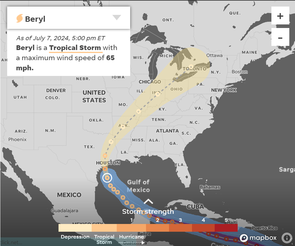
By 2:00 p.m. EDT, Beryl was positioned approximately 165 miles southeast of Corpus Christi in the Gulf of Mexico, moving in a northwest direction at 10 mph. The storm was forecasted to maintain this trajectory throughout Sunday and then shift to a north-northwest path by Sunday night.
Forecasters are predicting that the storm will hit the Texas coast early on Monday as it strengthens to at least a Category 1 hurricane. Storm surge, hurricane, tropical storm watches and warnings are in effect for the Gulf Coast of Texas. The storm surge is expected to reach up to 6 feet in some areas. Tornadoes are a possibility on Sunday, and rainfall amounts could be between 5 to 10 inches, with up to 15 inches in certain spots.
AccuWeather’s Carl Erickson warned that strong winds from the hurricane could lead to downed trees, power outages, and significant property damage. Some areas may experience power outages lasting for days or even weeks.
Beryl storm tracker
This forecast track shows the most likely path of the center of the storm. It does not illustrate the full width of the storm or its impacts, and the center of the storm is likely to travel outside the cone up to 33% of the time.
Texas gulf town in Beryl’s path braces, some flee
During a hectic Sunday morning at the gas station and convenience store he oversees in Palacios, Texas, Kevin Maredia only had a few minutes to spare. The town, located on the Gulf Coast with a population of 4,000, was in the path of Hurricane Beryl.
Worried drivers were stopping by to refuel before leaving town to avoid the storm, while other customers were stocking up on supplies in preparation for potentially riding out a Category 2 hurricane.
The store, located around 10 blocks from a bay that could face Beryl’s most intense winds, had its windows boarded up and will be closing at 7 p.m. on Sunday instead of the usual midnight, according to Maredia. He noted that discussions about the storm were frequent, with some customers expressing concern and even panic. “People are leaving because they believe the wind will be heading our way,” he observed, “so they’re choosing to leave town.”
Could Beryl rapidly intensify to a Category 2 hurricane?
Meteorologists anticipate that Beryl will likely strengthen back into a hurricane on Sunday afternoon or evening in the Gulf of Mexico, taking advantage of favorable conditions.
The latest forecast from the hurricane center suggests that it could become a Category 1 storm again, but there is a possibility of it reaching Category 2 status with winds exceeding 95 mph. The storm may experience a rapid intensification period just before it hits land, with a potential increase of over 35 mph in wind speeds.
Similar quick wind increases were observed when Beryl passed through the Windward Islands and entered the Caribbean.
What’s the difference between a Category 1 and a Category 2 hurricane?
Category 1 hurricanes have winds of 74-95 mph. Very dangerous winds will produce some damage: Well-constructed frame homes could have damage to roof, shingles, vinyl siding and gutters. Large branches of trees will snap, and shallowly rooted trees may be toppled. Extensive damage to power lines and poles probably will result in power outages that could last a few to several days.
Hurricanes in Category 2 are characterized by winds ranging from 96 to 110 mph. These powerful winds can cause significant destruction, such as major roof and siding damage to sturdy homes. Additionally, many trees with shallow roots may be knocked over, obstructing several roads. Expect widespread power outages, with some lasting for days or even weeks.
*****Original Post: July 1st, 2024*****
Hurricane Beryl-in Down the Caribbean
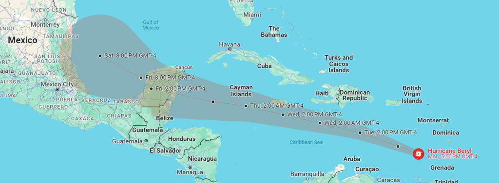
JULY 1, 2024: The first named hurricane of the season, Hurricane Beryl, is storming down the Caribbean, destroying everything in its path. Hurricane Beryl, which started as Invest 95 on Thursday. June 27, 2024, picked up strength on Saturday, June 29th, 2024 to become Tropical Storm Beryl, after accruing wind speeds between 39 to 73 mph. Over a period of 24 hours, Beryl intensified in a Category 4 hurricane, with maximum winds speeds of 153 mph. Meteorologists indicate Hurricane Beryl will continue to strengthen into a Category 5 hurricane as it leaves Granada devastated and proceeds toward Jamaica.
The latest on Beryl:
• Beryl is a dangerous hurricane: As of Monday evening, the storm was positioned 575 miles east-southeast of Isla Beata in the Dominican Republic, with sustained winds of 155 mph. It was moving to the west-northwest at 21 mph. Beryl’s hurricane-force winds reach 40 miles from the center, while tropical-storm-force winds extend about 125 miles. The storm is expected to move away from the southern Windward Islands on Monday night and travel across the southeastern and central Caribbean Sea by Tuesday. It is forecasted to pass near Jamaica on Wednesday.
• Life-threatening storm surge and flooding: The National Hurricane Center issued a warning stating that a life-threatening storm surge could elevate water levels by 6 to 9 feet above normal tide levels in areas with onshore winds near the eye of the hurricane making landfall in the warned area. The center also mentioned that significant swells from the storm will persist in the Windward and southern Leeward Islands for the next few days. Additionally, it was noted that these swells are anticipated to reach the southern coasts of Puerto Rico and Hispaniola by late tonight or Tuesday, potentially leading to dangerous surf and rip current conditions.
• Hurricane warning: Tropical storm warnings are currently in place for the south coast of the Dominican Republic from Punta Palenque westward to the border with Haiti, as well as the south coast of Haiti from the border with the Dominican Republic to Anse-d’Hainault. Hurricane conditions may be possible in Jamaica by Wednesday.

• Hundreds evacuated: More than 400 people were being housed in hurricane shelters.
• State of emergency in Grenada: The state of emergency declared by Grenadian Gov. General Cécile La Grenade on Sunday night will continue until Tuesday morning. All businesses, with the exception of the police force, hospitals, prisons, waste disposal, and ports, have been closed.
• Airports remain closed: As Beryl neared, airports in Barbados, Grenada, and Saint Lucia were shut down on Sunday night. A spokesperson stated that Grenada’s Maurice Bishop International Airport is set to resume operations on Tuesday morning. The Grantley Adams International Airport in Barbados, as well as St. Lucia’s Hewanorra International and George Charles airports, have also ceased operations.
• Cricket World Cup fans stuck: Barbados Prime Minister Mia Amor Mottley stated that cricket fans from various countries are still in the island for the T20 World Cup and some are not expected to depart until Monday or Tuesday. Mottley urged residents to assist visitors who may not have experienced a hurricane or storm before.
Beryl has broken the record for the easternmost hurricane to form in the Tropical Atlantic in June, surpassing the previous record set in 1933. If Beryl were to reach Category 5 status, it would only be the second time an Atlantic hurricane has achieved this strength in July, with the first being Emily in 2005 – making it the earliest Category 5 storm on record. The central and eastern Atlantic typically see increased activity in August as ocean temperatures rise, but this year has seen above-average water temperatures and reduced wind shear due to the transition from El Niño to La Niña, both of which contribute to tropical development.